A case of that was then, and now its now
I have been out revisiting some spots in the Burren that I haven’t been to for a while, and trying to get to some new ones. Its hard to drag yourself away at times but there are still spots on the maps that I haven’t been too. So the dilemma is go back to the spots with which I’m familiar, I know I will enjoy and there’s usually something new to be noticed. plus, in The Buren the change in the seasons and the light make places seem so different. But I also feel the need to go tick off some of the places I haven’t been to yet. One spot has been waving at me for a long time. It sits at the bottom of Turlough Hill, one of the regulars. Turlough Hill has a very large cairn on the top at one end, near by are the remains of approximately 80 hut sites. The first time I was on top of this hill, looking for the hut sites we meet a man with maps and charts and a stack of papers, he too was looking for the hut sites. he was doing a degree in archaeology, he showed us some bumps and put his red and white striped stick beside it and took a photo. That’s one of them he said, excitement drained quietly away as I looked at the non-de script lump, not very impressive.
But the cairn is fantastic, a little tumbled down to one side high and a very regular shape. What was the purpose of this edifice, tonnes of stones piled up and packed closely together. Was it a watch out point, a signal place, as far as I know there is no evidence of fires having been lit on the cairns. Or where they statements, this is ours and we can afford to spend all this effort to build this. Like the trophy homes of the Celtic Tiger. Was this the Celtic Giant Elk, a time of plenty and the desire to flaunt it.
But back to the hut sites. turns out that the hump we say was just that. A hump. On a subsequent visit we found the hut sites. So obvious you could fall into them. I don’t think our “oh, you can only really see them properly in aerial photos” student did too well on his field study project. now, the actual sites are to all intent and purpose still just bumps, but bumps that you can see where once the base of a hut, a home, a communal space, some are quite large. Its enough to give you the push to start speculating on the conditions and the people. They had to be well resourced, otherwise they could not have devoted so much effort to building the cairn. Did they have slaves? was there classes, or casts? Was there laws and were they the early versions of the Brethon Laws? Was there equality in the group, did they elect leaders or have chiefs? Its unlikely we will ever be able to do more than guess about these things but in a way maybe thats a good thing, in the end we can all have our own story of what it may have been like.
Now, I still haven’t gotten to the main point, the new place I was going to visit.In a way the way I’m distracted form the story is just the same as the way I end up going to the same place instead of somewhere new, every time there’s something new. So just one more thing on Turlough Hill, and yes, actually on Turlough hill. At the far end from the cairn is the remains of a very large stone fort, its rectangular and covers a very large area. It was only after a number of times on the hill that we found this fort, too long at the cairn and huts kept us away and weather also on another day. The day we did find it was a fine clear sunny day and it was again a wonder to behold. how many people lived on this hill and how many animals did they keep. Where the forts to prevent cattle raids so beloved of the tales of Cu Cullen and the sagas of ancient times. were the inhabitants of these forts and huts gone and forgotten by the time the dwellers of the site I’m going to get to soon arrived? It’s likely they were long gone, the upland farms existed when the valleys were still filled with trees. Did the upland dwellers move down and clear the trees, maybe when the weather got significantly wetter, about four and a half thousand years ago. Again speculation but its possible I don’t think they just left after being in the area for so long.
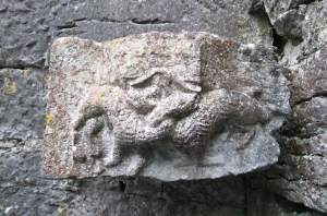
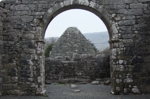
So, down into the valley, lush green fields divided by nice neat stone walls.on the edge of the fields just off the flank of the rough open hillside is the place I’m finally getting to. The approach is from the road not far from Corker Pass. As I walk up the step track passing great clumps of Cowslips I meet a farmer in a tractor who grins and opens the door; your looking for the churches. I am, I smile and for no good reason wave the map at him, secretly saying I know where they are, pride is a terrible thing but I say nothing. Well, when you see them, that’s not the way to go down to them. that’ll be the third gate, you need to go on to the forth gate, it’s very wet if you go the other way. he waves his wellies at me, these are what you need, looking at my walking boots. I feel judged but then that’s just me, these cost a lot of money you know. He is however a totally nice man, he waves me on with a friendly enjoy your walk. I forgive him all my imagined slights and head on. Four gates on and I can already feel this is an exceptional place. The first church is the oldest, most of the walls are gone except for the East gable with a very nice window. the next two churches are glimpsed through the trees and accessed via stiles in the walls. These are almost end to end. Again it’s impossible not to start populating this place with monks craftsmen, farmer monks and no doubt there were pilgrims passing. There is also the site of a mill, with a millrace running to near the churches. The mill was fed by springs on the hill and would have required water to be collected for release, then another collection period as the flow is not very voluminous though it would be reasonable after a lot of rain. I assume again they ground corn after the Autumn harvest. Did they make beer as many of the Monks on the Continent still do? As I wander back and fourth I can see that this was a wealthy monastery. The last church in the series is the largest and has been extended. The stone work is of a very high standard and there is a water font carved with entwined animals.
The north wall faces the approach, the huge stones used are fitted together with tight joints and is extremely impressive. The door is facing west with the alter window facing east. The most interesting wall is the south facing one. at first its the two windows, they got that right. Windows facing the best source of light and the warmest, passive has been around for a long time.
But, then an epiphany. Now people assume that an epiphany in a place like this has got to be a religious conversion or something of that ilk. But no that’s just that the word has been subsumed into the lexicon of religion as a revelation that converts someone to religion. But this one is of the opposite type. The south wall, the one not seen by the “public” as they approach the church is built of the same very large stones but these have wide joints filled with mortar and spalls. This wall was built to a lower standard because it would not be seen. So why are churches built in such an elaborate fashion? For the glory of god or for the ego of the builders? well did they believe they could hide the poorer quality work from god, while telling everyone else that god sees all their sins? It may be a small thing, but its an indication of how the powers of the church thought just under a thousand years ago and has that changed? Can the past inform the present? I think so, the church should know they can’t fool their own god and now they should also know . . . they can no longer fool the people either.
The place itself, Ucht Mama and it is a lovely place to visit and as long as your not a bit cranky like me, its very relaxing.


